Hello friends! 30 July 2025 has become a historic day for India and the world. On this day, NISAR, a joint satellite project by ISRO and NASA, was launched successfully from Sriharikota. The satellite is special because it can give early warnings for natural disasters like earthquakes, tsunamis, floods, and landslides. After the massive 8.8 magnitude earthquake near Kamchatka, the need for such a system became very clear. So let’s understand what NISAR is, how it works, and why it is a big achievement.
What Is NISAR And Who Made It?
NISAR means NASA-ISRO Synthetic Aperture Radar
It is a joint mission between India’s ISRO and America’s NASA
It is one of the world’s most advanced radar observation satellites
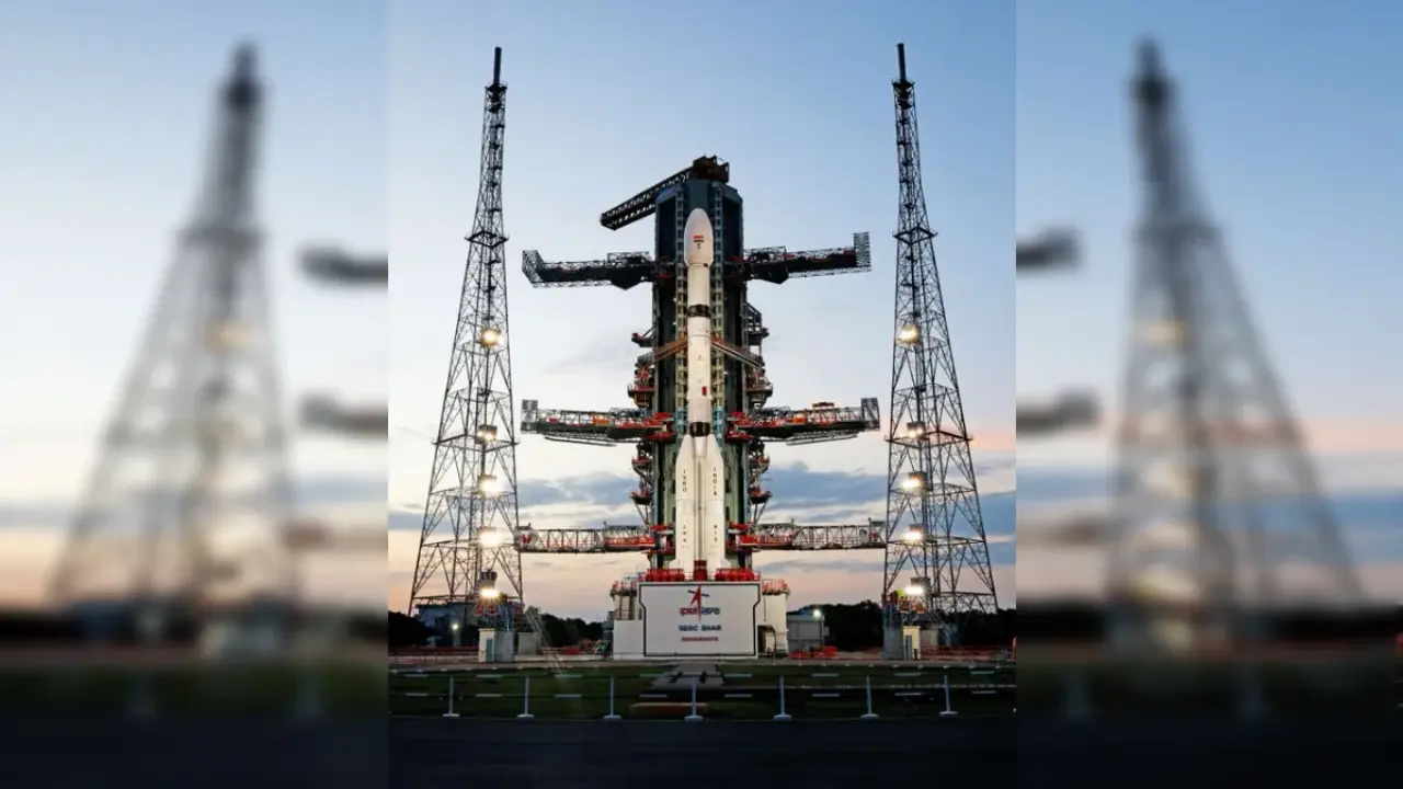
Launched on 30 July 2025 from Satish Dhawan Space Centre in Sriharikota
It was sent to Sun-synchronous orbit using ISRO’s GSLV-F16 rocket
The satellite weighs about 2,800 kg and uses powerful radar technology
How Will NISAR Help Predict Earthquakes And Tsunamis?
It detects small movements in Earth’s surface before earthquakes
It can sense early shifts in fault lines under the ground
It monitors ocean surface changes that signal a tsunami
It can warn before waves or tremors actually hit land
It improves the time gap between disaster and alert, saving lives
Why Was NISAR’s Launch So Important After Kamchatka Quake?
On the same day—30 July 2025—a powerful 8.8 earthquake hit near Kamchatka
It affected at least 12 countries around the Pacific
Many areas faced tsunami warnings and fear of aftershocks
NISAR’s timing shows how early warning is necessary for such disasters
With NISAR now in space, future warnings can come much faster
What Disasters Can NISAR Monitor For India?
Himalayan earthquakes in North India
Floods in Assam and Kerala during monsoons
Landslides in Uttarakhand and other hilly areas
Cyclones along India’s coastal regions
Earth movements in tectonic-sensitive zones
What Are The Benefits Of NISAR For The World?
Early alerts for earthquakes and tsunamis in many countries
Data for weather experts and scientists worldwide
Supports emergency planning and disaster response
Helps understand climate change and ice movement
Improves safety in earthquake-prone and coastal areas
How Does NISAR Technology Work?
Uses dual-frequency radar—L-band and S-band
Captures clear radar images day and night, in any weather
Takes large-area images every 12 days for better monitoring
Can track even tiny land shifts of just a few millimeters
Delivers high-resolution data to ground stations globally
What Makes NISAR Unique Compared To Other Satellites?
It is the first radar satellite developed by both ISRO and NASA
It uses two radar systems in one satellite
Covers large areas with better speed and clarity
It combines Indian and American space technology strengths
Built specially for disaster prediction and earth monitoring
Why Should India Be Proud Of NISAR?
India played a big role in building and launching the satellite
It shows India’s power in global space cooperation
India will now lead in space-based disaster warning systems
Indian scientists worked closely with NASA on this mission
It supports India’s safety from floods, landslides, and earthquakes
What Comes Next After NISAR Launch?
Data will be collected and shared with agencies and researchers
India will set up disaster alert systems using NISAR data
NISAR will become part of India’s climate and disaster control plans
Other countries may partner with India for using NISAR data
New space missions may now be inspired by NISAR’s success
Related Searches: NISAR satellite launch 2025, ISRO NASA NISAR project, how NISAR helps in earthquake alerts, NISAR and Kamchatka tsunami, Kamchatka 8.8 earthquake news, NASA ISRO space mission, early warning satellites 2025, NISAR radar technology, GSLV-F16 rocket launch, Indian satellites for natural disasters, NISAR tsunami detection, fault line monitoring satellite, NISAR orbit location, NISAR weight and size, NISAR images of Earth, Himalaya earthquake prediction satellite, flood detection by satellite, NISAR India USA partnership, NISAR real time alerts, landslide prediction system India, coastal tsunami alert satellite, ISRO’s biggest satellite, radar satellite for climate change, NISAR coverage area, Earth observation radar 2025, NISAR vs other satellites, future of disaster warning satellites, India USA space missions
FAQs
Q1. What is NISAR satellite?
It is a radar satellite made by ISRO and NASA to detect natural disasters early.
Q2. When was NISAR launched?
It was launched on 30 July 2025 from Sriharikota, India.
Q3. How will NISAR help in earthquakes and tsunamis?
It can detect early surface shifts and give warning before disasters strike.
Q4. What technology does NISAR use?
It uses dual-frequency radar (L-band and S-band) for advanced monitoring.
Q5. Why is NISAR important for India?
It will help warn people in disaster-prone areas like Himalayas, Assam, and Kerala.
Param Express took best research efforts from top official websites to check this info and bring it to you in the easiest way. Readers are advised to follow ISRO and NASA’s official updates for the most accurate and latest developments related to NISAR and other space missions.
Also Read: Brendan Taylor’s Comeback Shocks Cricket World After 3.5-Year ICC Ban